

Uploading GIS data to GeoNode
“GeoNode is an Open Source Geospatial Content Management System”
Resources representing raster or vector spatial data which is published to GeoNode are referred to as Layers. Each layer can be associated with distinct metadata, ratings, and comments on the GeoNode platform. This module outlines the workflow for uploading spatial data into GeoNode, which will create a new layer for each of the uploaded data sources.
You try:
Goal: To upload and visualize GIS datasets in GeoNode
Uploading layers
A high level overview for the layer creation process is as follows:
- Login to the relevant GeoNode instance
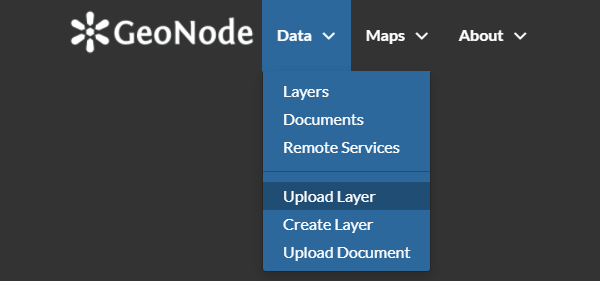
- Navigate to the Upload Layer page from the Data menu
- Select the relevant layer from the exercise folder
You may review the data by selecting the Layer Info tool, which will generate a preview of the layer in a live web map view.
Task
Try to perform a data upload for the following data sources available from the exercise folder:
- ne_10m_admin_0_countries.shp
- ne_10m_admin_1_label_points.zip
- ne_10m_railroads.geojson
- srtm_41_19
Note that a single shapefile consists of numerous auxiliary files, all of which will be uploaded as a single layer in order for the data to be recognised as valid content.
Check your results
Are you able to visualize all the layers you have uploaded to GeoNode?
If a layer is not able to be visualized, can you identify the possible reasons why?
Why are the symbologies different between vector and raster layers?
| Name | Expectation |
|---|---|
Layer type |
Raster, Vector |
Layer formats for GeoNode |
GDAL and OGR compatible formats |

More about uploading resources
GeoNode supports uploading and managing different types of resources. The two primary resource types are:
- Layers - This represents spatial information so that it can be displayed within the web map viewer. This may be either vector or raster data.
- Documents - This represents non-spatial data files that can be stand-alone, or associated with spatial layers or maps.
GeoNode uses the popular library GDAL to read raster and vector data. Although GDAL can read many different data formats, GeoNode defaults to supporting only a subset of them for stability purposes. If you intend on utilising other spatial data formats which are not of the official recommended daata types, many formats may work but it is not guaranteed that all functionality will perform as expected.
As a result, although not strictly necessary, it is recommended that data conversion into one of the recommended data types takes place before publication using software such as the GDAL library or a Desktop GIS application like QGIS Desktop.
The following vector data formats are recommended:
- Esri Shapefile
- Geojson
- KML/ KMZ
- CSV
- GML
- Compressed vector data sources (e.g. zip) for large vector uploads.
The following raster data formats are recommended:
- Geotiff with the extensions
tif,geotiffortiff

Check your knowledge:
-
Can a user who is not logged into GeoNode upload their layers:
- Yes, since it's open source there are no restrictions
- No, your user account needs to be granted the relevant permissions to be able to upload data by a GeoNode administrator
- Yes, GeoNode administrators can enable public uploads from within the GeoNode administration interface
-
Can I upload a zipped file containing raster data into GeoNode:
- Yes, this is possible in the same manner used for vector data
- No, this functionality is specific to vector data
- No, raster layers have compression applied to the data format
-
Can I upload a proprietary raster format in GeoNode:
- Yes, as long as it is a raster layer
- No, because the underlying software cannot read that type of data
- Yes, if you can view it in QGIS then it is possible

Further reading:
Download the sample data for the lesson.