

Uploading a layer to GeoSAFE
“In this module we will look at how to upload layers into GeoNode along with their QGIS Styling, InaSAFE keywords and other Metadata so that they can be used in GeoSAFE.”
You try:
Goal: To learn how to upload layers in GeoNode
- Log into an instance of GeoSAFE on the web browser.
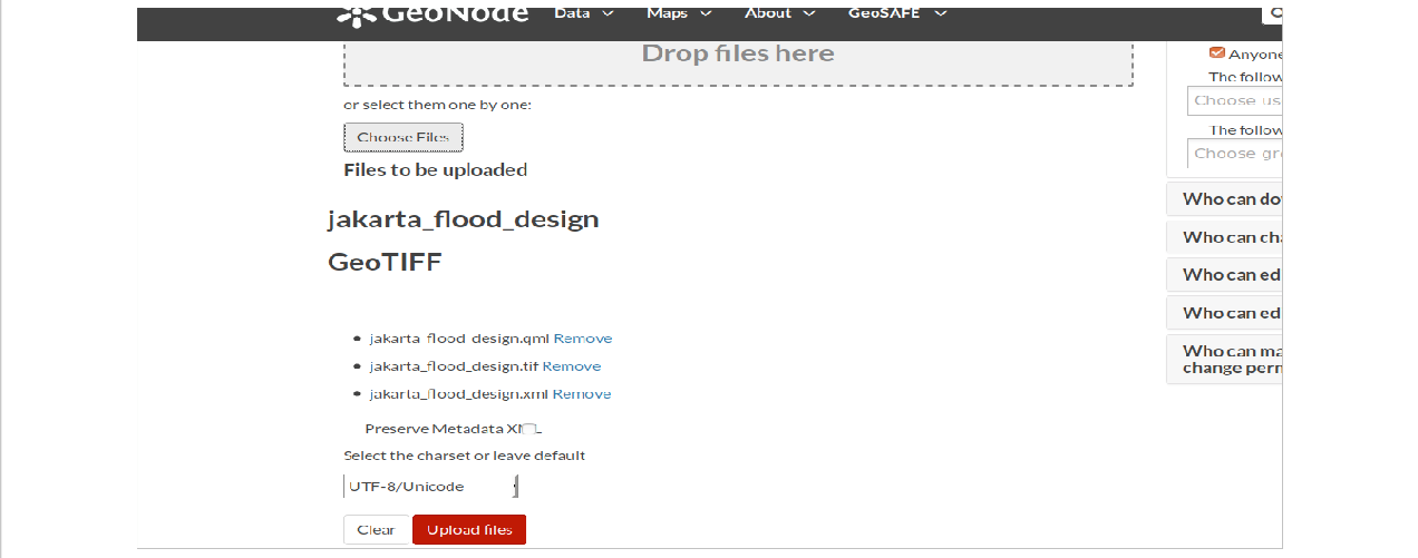
- Click on the Data menu and select upload layer.
- In the upload dialog navigate to the file system and choose the layer you need to upload. Make sure to also select the files with extensions shown in the table, right.
- Click upload layer
Note: Do NOT tick Preserve metadata
- After the upload finishes you can proceed to edit the metadata or change the styling options. However, leave them for now and proceed to view the layer in GeoNode and browse its metadata.
Check your results
After the upload finishes a menu option should open up which allows you to further edit the properties of the layer you have just uploaded. Go to layer previews and see how the layer looks.
- Is the correct layer drawing?
- Does it have the style you created in QGIS?
- If you look at the Detailed Metadata and scroll to the bottom, can you see your InaSAFE keywords?
More about
GeoSAFE consists of the components Django, Geonode and QGIS server with the InaSAFE plugin. Because QGIS is the map server behind GeoSAFE, users are able to upload layers with layer styles (symbology) that have been generated in QGIS and they can immediately visualise the layer as if they were viewing the layer on the desktop. The metadata generated by InaSAFE and MetaTools on the desktop is also ingested with the layer.

Check your knowledge:
-
What do you understand from the term layer style:
- Graphic icons and shapes that are used to denote the appearance of vector or raster features in a GIS
- A type of GIS dataset that is available in GeoSAFE
- A type of file that resembles a metadata document
-
Which of the following statements is true:
- GeoSAFE and InaSAFE do not do the same thing
- GeoSAFE analysis can be run using a layer on your desktop like InaSAFE
- In order to use GeoSAFE you need to upload a layer with the right keywords
-
How does one generate a layer style file (.qml):
- Exporting it from QGIS
- You need to be a programmer and write it using some code
- Neither of the above

Further reading:
-
advanced-layer-styles-in-qgis https://anitagraser.com/2010/12/15/advanced-layer-styles-in-qgis/