

How flood data are prepared for InaSAFE Realtime
“In this module we will explain how flood data are extracted from PetaBencana and prepared for use in InaSAFE Realtime.”
In flood realtime, an hourly check is made against PetaBencana to see if there are any flooded RW boundaries recorded for the last hour. These are recorded in the InaSAFE Realtime database. Every six hours, another check is made against the InaSAFE Realtime database to see if there were any floods recorded over the previous six hours. If there were, an InaSAFE report is generated. In this worksheet we will explore the flood section of the InaSAFE Realtime web site. This is described in the diagram below.

You try:
Goal: To understand how the determination of flooded RW’s is made
Use the table to calculate how many RW’s will be shown as flooded in the report generated at 12 pm.
Check your results:
Swap your list with a neighbouring group and see if they had the same results as you.
| Name | Expectation |
|---|---|
RW01, RW02, RW03 reported flooded in PetaBencana |
1 pm |
RW02, RW03, RW04 reported flooded in PetaBencana |
2 pm |
RW02, RW03, RW04 reported flooded in PetaBencana |
3 pm |
RW03, RW04, RW05 reported flooded in PetaBencana |
4 pm |
RW04, RW05, RW06 reported flooded in PetaBencana |
5 pm |
RW05, RW06, RW07 reported flooded in PetaBencana |
6 pm |
More about
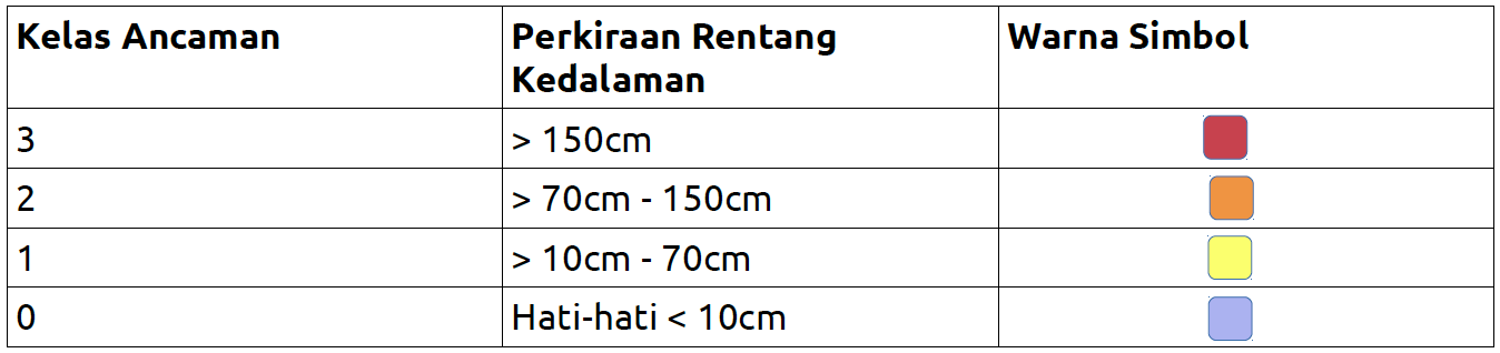
The number of affected RW’s is calculated as the total number of RW’s that had a Hazard Class zero or above in the 6 hour reporting window. The diagram describes the relationship between hazard classes and flood depths.
These classes are defined by PetaBencana. Any hazard class that is present is considered flooded (including 'use caution') for the purposes of reporting.
An event ID is generated by InaSAFE Flood Realtime in the form of :
So for example the following id: 20170221120000 represents a flood report for the 21st of February 2017 at 1200hrs. Currently there is no standard in place for flood event ID’s so this is a naming convention specific to InaSAFE Flood Realtime.
To prevent redundant storing of data, InaSAFE Realtime has an internal database of RW boundaries. Whenever an event is found in PetaBencana, the RW number is used to cross reference which geographical boundary that event is associated with and then a record is made that there was a flood recorded on the event date for that boundary. In other words, we have a normalised database behind InaSAFE Flood Realtime. One thing to bear in mind with this approach is that changes to RW boundary delineations should be consistent in BPBD-DKI, PetaBencana and InaSAFE Realtime.

Check your knowledge:
-
If the hazard class for an RW is 0 it is considered ‘not flooded’ and will not be included in the flooded RW count for that event:
- true
- false
-
Mark all the correct statements:
- Any RW that is not currently flooded at the time the six hourly report is generated will not be counted
- You can also fetch the history of floods from PetaBencana.id
- Flood Realtime will carry out its analysis when a user triggers it by pressing a button on the web site.

Further reading:
-
The InaSAFE Flood Realtime Web Site: http://realtime.inasafe.org/realtime/flood
-
The repository for InaSAFE Realtime website source code: https://github.com/inasafe/inasafe-django