

Network Analysis in Context
“A network is a set of connected lines. The networks are usually used to delineate rivers, road network. Network analysis studies the relationship between connected lines in terms of distance and time”
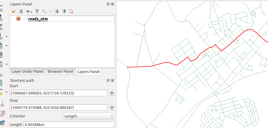
In this module, we look at how we can use QGIS to plan a route based on the shortest distance or the shortest time it takes to travel between two connected lines
You try:
Goal: To learn how to use the road graph plugin to calculate routes between two places.
Data: appendix3-local-data
- Open a new project and load the network layer.
- Activate the Road Graph Plugin.
- Project the network layer to the specified CRS (name the resultant layer roads_utm_33s)
- Navigate to the vector menu and choose Road graph settings
- Click on the default tab and choose the speed
- Click on a start in the Road graph panel and choose a starting point on the network (Use the projected layer)
- Choose stop and activate it on the network
- Choose the either of the criterion.
- Repeat the procedure using different criteria.
NB: Explain your results in terms of distance and time
| Name | Expectation |
|---|---|
Speed |
60 km/hr |
Network layer |
roads_osm.shp |
CRS |
UTM 33S WGS 84 |
Criterion |
Length/time |
More about
Network analysis aims to establish if you can move from A to B and from B to C and is it possible to move from A to C. Network analysis is a type of connectivity analysis. Network analysis varies from simple analysis to complex analysis.
Complexity is achieved by analysis of the network and checking for features which give resistance to a route. Examples of features that bring resistance are the number of traffic lights and terrain, and this affects determining the shortest path between two points in a network. Travelling cost also vary because of these factors.

Check your knowledge:
-
Which of the following statements is true:
- A network should be uni directional. All roads should be travelling in the same direction
- A road network can be bidirectional. A road that goes in both direction
- A vector layer that has units as decimal degrees can be used when estimating distances
-
Can a river be described as a network in the same way a road is:
- No we cannot determine the shortest path between two points because people do not travel in a river
- Yes, a river is a network and all operations done on roads can be done here
- A river is a GIS data depicting natural phenomenon so it cannot be used
-
Plugins are only installed when online:
- True
- False

Further reading:
-
Vector_network_analysis: https://grasswiki.osgeo.org/wiki/Vector_network_analysis
-
Grass.osgeo.org: https://grass.osgeo.org/grass73/manuals/wxGUI.vnet.html
Download the sample data for the lesson.