Project: InaSAFE
Changelog for version: 4.1.0
Release date: 26 May, 2017
This release introduces new functionality for dealing with population vulnerability. It also adds further polish to the reporting outputs and help documentation of InaSAFE. In addition to the items listed below, we have also spent a lot of time polishing reports and algorithms for improved logical consistency better formatting etc. Also please note that due to persistent layout issues with the infographics, we have disabled the infographic report for the interim - will will re-introduce them in a future release once we have resolved the issues.
Tools
We have made further improvements to the help system with better indexing of topics and improved visual appearance.
Documentation
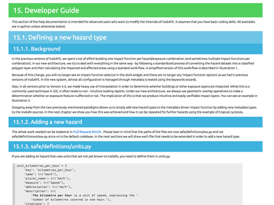
The help documentation now includes a small guide for developers wishing to add a new hazard type to InaSAFE.
Reporting
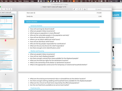
We have updated the generated report for actions and checklists to make it easier to read. Items are now grouped by topics with subheadings as illustrated in the screenshot here.
In previous versions of InaSAFE it was difficult to take a QGIS project containing analysis results to another computer since the html reports contained fixed paths to the InaSAFE plugin directory on the computer where the reports were generated. In InaSAFE 4.1 the images and styles used in the analysis report are copied into the working directory so that copying the whole working directory to another PC will allow you to open and view the html reports (e.g. by clicking on an impact layer in QGIS) and see the reports with their original formatting.
It is now possible to generate a quick PDF from any of the report and help dialogs by using the right click menu as illustrated in the screencast here.
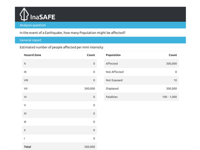
As part of the reporting improvement process we have included a list of terms underneath tables where appropriate. The intent is to make it very clear what the various versions concepts alluded to in the reports mean. In cases where report tables are based on fatality or displacement rates, we are also including the rates used in the notes section of the report to make it clearer how the numbers were computed.
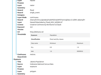
When you run an analysis, it is important to know which layers, thresholds, value mappings and so on were used. In InaSAFE 4.1 we have added a new report (accessible when you press the print button) which provides a detailed account of all the settings that were in place when the analysis was run. The provenance information is shown in a tree format, grouped by hazard, exposure, aggregation, general environment and so on.
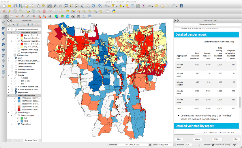
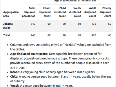
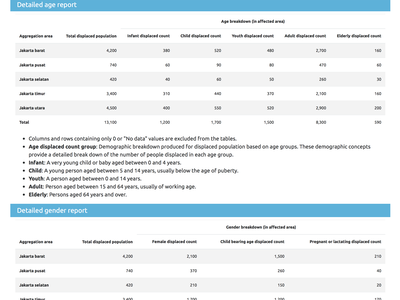
In InaSAFE 4.1 we introduce new capabilities for rich reporting of displaced people. The new field mapping tool allows you to identify attributes in your exposure population dataset that represent specific vulnerability attributes e.g. infants, disabled people etc. These attributes will then be used to provide detailed breakdowns of the different vulnerable groups, by aggregation area in the final report. In cases (e.g. raster population data) where these attributes are not available as part of the exposure dataset, ratios can be defined in the aggregation layer keywords to specify which proportion of the population in each area comprises each vulnerable group.
There are several components to this new functionality:
- a new tool on the InaSAFE toolbar called the 'Field Mapping Tool' which can be used with an aggregation or exposure layer that already has InaSAFE keywords defined. This tool lets you quickly adjust the field mappings, ratios etc. that are used for calculating vulnerability report.
- a new step in the keywords wizard that integrates the Field Mapping Tool described above
- A new tab in the InaSAFE options dialog that allows you to define the defaults that should be used for ratios.
- New reporting elements in the reports generated by the InaSAFE analysis that report on the vulnerable groups per aggregation area.
We have made a detailed walk through of this new functionality in the video provided below.
Issues
- Fixed an issue where InaSAFE options for organization etc. were not being correctly written to ISO metadata (#3878)
Impact Functions
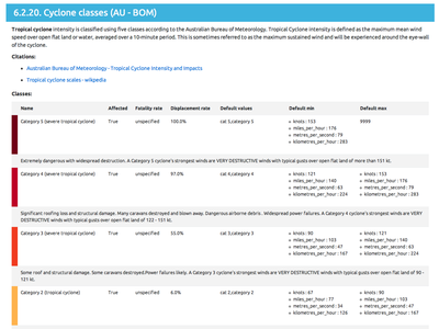
The wind speed averaging time periods for tropical cyclone have been standardized as per comments in #3802. All wind speed classifications now assume the winds are representative of a 0.2 second gust wind speed. Users will need to convert TC hazard layers to this wind speed averaging time period before importing into InaSAFE. Recommend there be a pre-processor that converts between different wind speed averaging time periods in future releases.
This feature was funded by Geoscience Australia/PacSAFE
This feature was developed by Craig Arthur
In previous versions of InaSAFE, choosing an earthquake impact model required that you understood the names and implications of each model. In InaSAFE 4.1 we have included a description underneath the model selector that updates when you change the default model.
We have added a new options panel to support setting default ratios for demographic breakdowns (see the accompanying section on that). In this panel you can set fallback ratios for cases where you indicate that you want to use global defaults in the aggregation layer properties.
In versions prior to 4.1 we did not yet support calculation of fatalities when doing an 'earthquake on vector population' analysis. This is now supported in version 4.1 going forward. The fatality rates are determined by the active fatality rate function - as selected in the InaSAFE options dialog. This is the same logic used for earthquake on raster population.