
About the OpenStreetMap project
“OpenStreetMap (OSM) is a collaborative project to create a free editable database of the world”
This crowdsourced data is made available under the Open Database License (ODBL). The project is supported by the OpenStreetMap Foundation, a non-profit organisation based in England. Data is collected from scratch by volunteers performing ground surveys using tools such as a handheld GPS unit, a notebook, a digital camera. Now, we can also use some external datasource such as satellite imagery or local dataset.

You try:
Goal: Check the content of the OSM database and how data are structured.
Go on osm.org and zoom in your area (a few houses for instance).
- Check the link called “Copyright” on the right top corner. What can you legally do with OSM if you respect some conditions?
- Does the map look complete? Is your house on the map? Is there every roads, even small paths?
- Display the layer “Map Data” and click on some blue objects on the map. These are called features.
- Click on a building, observe its tags on the left panel. Write down on your bloc-note some tags.
- Do the same operation with a road.
- Look at the OSM wiki how we tag highways and buildings.
- Form a small group and explain how these tags work and what kind of geometry is associated with these OSM objects. Let’s sum up this together.
| Name | Expectation |
|---|---|
Website ❗ |
www.openstreetmap.org |
Layers ❗ |
Display “Map Data” |
Key “building” ❗ |
http://wiki.openstreetmap.org/wiki/Key:building |
Key “highway” ❗ |
http://wiki.openstreetmap.org/wiki/Key:highway |
More about
OpenStreetMap is not a map, it’s a massive database of geographic data, and it’s all open and free. A feature is describing an object from the real world using some tags. These tags are composed of a key and a value. These keys are normalized by the OSM community and are described on the OSM wiki. The value is also normalized except a few one like the value of the “name” key. As an example, so as to describe a road, we should use at least the first tag. All other tags are optionals:
| Key | Value |
|---|---|
| Highway | Residential |
| Name | Nelson Mandela Street |
| Surface | Concrete |
| Oneway | Yes |
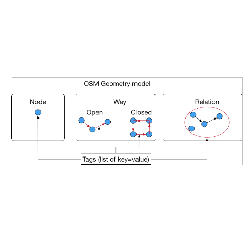
On the OSM database, you can find three kinds of geometric objects:

Check your knowledge:
-
OSM is a database where:❗
- You can store vector data
- You can store raster data (satellite imagery)
- You can use it for free if you mention the OSM attribution in your results and you respect the license

Further reading:
-
beginner: http://learnosm.org/en/beginner/ ❗
-
know more about OSM objects http://wiki.openstreetmap.org/wiki/Elements ❗
-
About tags http://wiki.openstreetmap.org/wiki/Tags ❗