Project: InaSAFE
Changelog for version: 3.2.0
In this release we have made over 1200 commits to our code base, making improvements to almost every part of InaSAFE. Whilst some of these improvements are visible through the user interface and reports we generate, the vast majority of the changes in this release are architectural improvements, bug fixes and improvements to the speed and quality of the code that underlies InaSAFE. This release has also been subject to a large Quality Assurance review - we are working very hard to improve the quality and consistency of analysis results with each release.

We have not only been working hard on the main InaSAFE plugin, but also in revamping the InaSAFE.org web site, building a new InaSAFE realtime web site, sprucing up our user map (please add yourself there if you use InaSAFE!), overhauling the [documentation] (http://docs.inasafe.org).
InaSAFE is an Open Source project and we would like to encourage organisations and individuals interested in the project to get involved. Visiting our chat room or contacting us via info@inasafe.org is a good place to start the conversation!
Tools
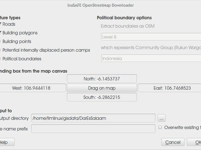
InaSAFE 3.2 introduces a new and improved OpenStreetMap data downloader. We have added support for dowloading potential Internally Displaced Persons (IDP) camps and for downloading political boundaries.
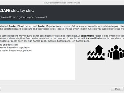
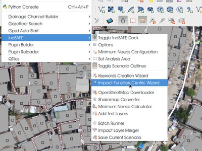
The Impact Function wizard has been improved. It has been themed to match the theming updates made elsewhere in the application. In addition the following tweaks have been made:
- Removed Single/Multi Event radiobuttons
- Provided an explanation why when a layer is not selectable
- The browser no longer displays the tons of .xml files in a directory
- Layers with obsolete keywords are treated like they were keywordless, with one difference: the description says the keywords are obsolete, not missing. The text is based on that one from the dock - see attachment.
We have tidied up the InaSAFE menu (Plugins -> InaSAFE) to make the menu organisation more logical. We have also remove items from the InsSAFE toolbar and improved the order of toolbar items so that they options are arranged more logically. You will notice that the iconography for all menus and toolbar buttons has been overhauled for consistency and clarity. Menu items are arranged using the following groupings:
- Configuration related options
- Wizards
- Tools for adding data to InaSAFE
- Miscellaneous helper utilities
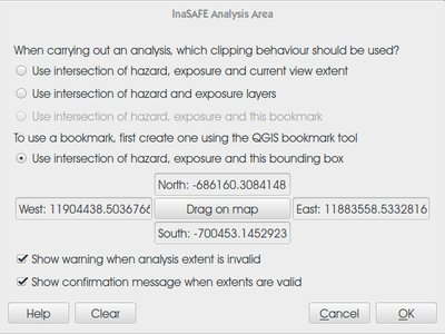
In previous versions of InaSAFE, the options that governed the definition of analysis extents were spread across different dialogs and it was not intuitive to understand how the various options interoperated. With InaSAFE 3.2 we present a new analysis extents definition tool that addresses these issues. In addition, the new extent selector allows you whether to enable notifications which will inform you when the extents are suitable for use in an analysis - and when they aren't.
We have systematically revised the theming of the InaSAFE user interface, reports generated, dock reports etc. We have also revised many of the textual elements that are presented at different points through the InaSAFE workflow in order to make the experience of using InaSAFE more consistent and clear. The new modern look is also crisper and provides a more modern look and feel.
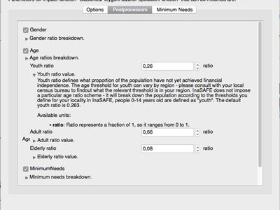
Users who need to adjust the parameters of impact functions prior to running their analyses will be pleased to note that we have overhauled the InaSAFE Options dialog. Not only have we improved the visual representation of Impact Function paramters for Options, Postprocessors and Minimum needs, we have also also taken a lot of effort to simplify things, reduce confusion and improve consistency and efficiency. For example where impact function options can be gleaned from the input layer keywords (e.g. which field in a flood layer marks a feature as flooded), we use the layer keyword rather than asking users to enter duplicate information. We have also removed potentially harmful parameters that could cause our users to create poor analysis results if changed.
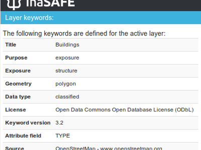
InaSAFE 3.2 introduces keyword versioning. If you have used previous versions of InaSAFE to define keywords for your layers, you will need to update the keywords before you can use those layers in InaSAFE 3.2. InaSAFE will now automatically add a version keyword to your layer keywords. In future versions this will help us to automatically migrate your keywords to new keyword formats if needed, and alert you if your keywords are too old to be used with the InaSAFE version you have.
We have spent some time polishing the experience of creating the keywords using the keywords wizard, and improving the presentation of keywords in the dock when a layer is highlighted. We have also hidden away the internal keyword names and added functionality to present the keyword names in a more human and understandable way.
In previous versions certain configuration options for impact functions were configured directly on the impact functions dialog. This approach was cumbersome as repeated use of the same impact function required re-setting the same options each time. With 3.2 we have moved many of the configuration options to the keywords system For example setting the floodprone attribute for a polygon flood layer in the layer keywords will automatically cause the impact function to recognise that attribute in the keywords.
See this video for a run through of how the keywords look for different input layers
Website
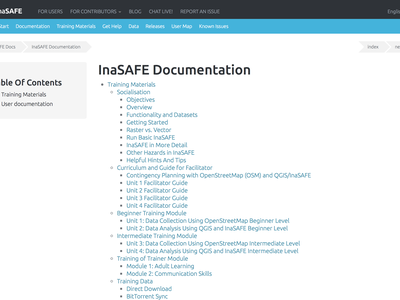
We have completely reviewed the documentation for this release. The documentation team has been working hard to freshen up the documentation to make it more consistent with the new features in InaSAFE. The training materials are also being updated to emphasis use of the keywords and Impact function wizards. The new curriculum will be used as the basis for future training courses. The ‘socialisation’ documentation (which is intended to provide an introductory overview of the InaSAFE project and its capabilities) has also been completely overhauled.
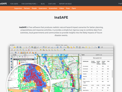
We are pleased to present our brand new web site at InaSAFE.org. The new web site sports a new theme which is consistent with our efforts to present a unified branding throughout the InaSAFE project. We have also tried to group the content in a clear, logical way. We hope the overhauled web site provides a better first impression for new users to the InaSAFE project and makes it easier for existing users to find the information they need.
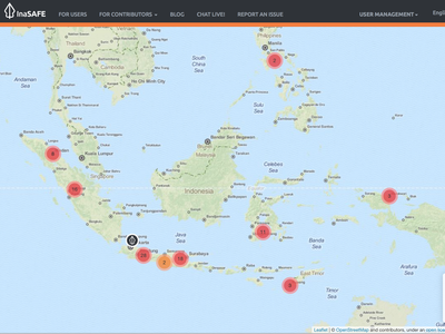
We have updated the user map, making it more attractive and more in line with our web presence overhaul. Please take a moment to add yourself to our map if you are a not yet on it!
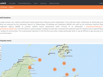
We have completely overhauled the InaSAFE Realtime web site. The previous version of the web site provided a simple static list of earthquake impact reports. With the new version of the realtime web site, you can now browse, filter and query shake events both in a dynamically updating table, and by interactively viewing the events on a map. Having a map of events provides spatial context making it possibly to better understand the spatial component of historical earthquake events around Indonesia. For developers, the new web site also provides a REST API so that third party applications can consume and public realtime disaster events to and from the web site.
Reporting
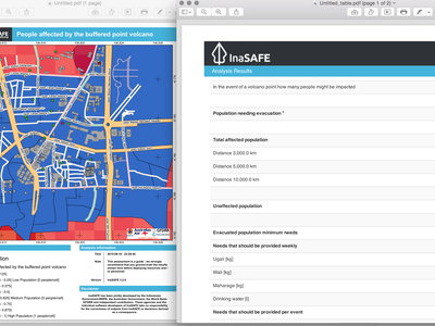
For this release, we have added several new print composer templates that you can use to generate reports after an impact function has run. We welcome additional contributions of templates, so please share your templates with us if you made new ones! For advanced users, we have also added more composer elements and replacement tokens in our templating system. Please see our templating guide guide for more details. Here is a list of the default templates shipped with InaSAFE as of version 3.2:
Blue variants
- A4 Landscape - Blue Variant
- A4 Portrait - Blue Variant
- A3 Landscape - Blue Variant
- A3 Portrait - Blue Variant
Orange variants
- A4 Landscape - Orange Variant
- A4 Portrait - Orange Variant
- A3 Landscape - Orange Variant
- A3 Portrait - Orange Variant
Issues
InaSAFE is a work in progress. We are trying to make the best and most robust software possible, whilst still making regular incremental improvements available to you our beloved user. The following issues should be borne in mind whilst using InaSAFE 3.2:
- In some cases the reported numbers for the entire analysis may differ from aggregation totals due to the fact that the entire analysis may include data not covered by any aggregation area.
- In some cases the report table may be truncated if it includes too many categories to fit within the width of the page. We are working on ways to resolve this issue in the future by for example, reducing the number of classes reported on, presenting data in other ways such as charts / infographics etc.
- Keywords created in older versions of InaSAFE will not be compatible with InaSAFE 3.2 - you will need to recreate your keywords using the keyword wizard.
- On the fly reprojection of data is not yet reliable / usable.
- Some Impact Functions make use of interpolation to determine e.g. the flooded status of a building. This interpolation may make the results difficult to interpret in some cases. For example, a building may be marked as flooded on the map even though it appears to not be overlaying a flooded data cell in the flood raster.
- Map legends do not remove outliers. In some cases a single high value pixel (e.g. number of people affected by flood in a cell) may cause the scaling of the legend to be skewed in a way that makes it difficult to discern localised minima / maxima.
Impact Functions
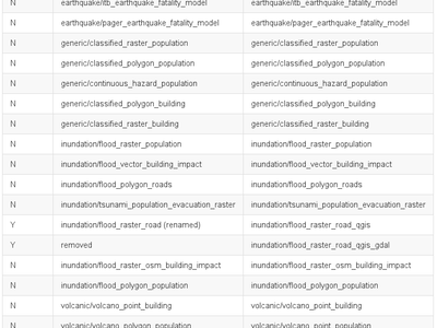
In InaSAFE 3.2 we have not added any new Impact Functions but we have made many refinements and improvements to the existing ones. We have also removed one Impact Function (inundation/flood_raster_road_qgis_gdal) to remove duplication and renamed one (inundation/flood_raster_road renamed to inundation/flood_raster_road_qgis) to make the nomenclature more consistent. As of version 3.2 we have 19 impact functions covering generic, inundation (flood and tsunami), earthquake and volcano hazards (see image for a complete list or this gist for the text version).
We have put a lot of work into improving the underlying architecture of Impact Functions so that code reuse is maximised and that they are described with rich, expressive metadata.